

The joint NASA–ISRO Synthetic Aperture Radar (NISAR) satellite has returned its first striking images of Earth, offering a preview of the cutting-edge science the mission will deliver when it enters full operations later this year.
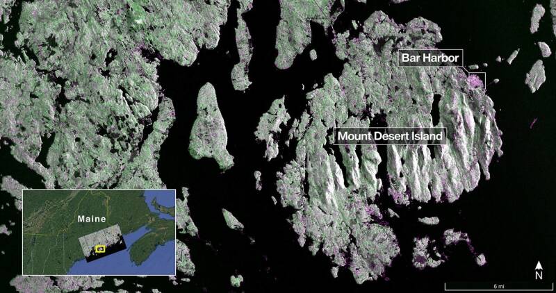
Captured on Aug. 21, this image from NISAR’s L-band radar shows Maine’s Mount Desert Island. Green indicates forest; magenta represents hard or regular surfaces, like bare ground and buildings. The magenta area on the island’s northeast end is the town of Bar Harbor.
Credit: NASA/JPL-Caltech
Launched by the Indian Space Research Organisation (ISRO) on July 30, the spacecraft is designed to transform how scientists and policymakers monitor natural hazards, ecosystems, and agriculture. Its dual-band radar system — the first of its kind in orbit — will allow the mission to track changes in Earth’s land and ice surfaces with unprecedented precision.
“These images are proof of what’s possible when nations collaborate in pursuit of discovery,” said acting NASA Administrator Sean Duffy. “NISAR is only just beginning to show its potential as a gold standard for Earth science, while also reinforcing America’s commitment to leadership in space innovation.”
The satellite’s first observations came in late August. On August 21, NISAR’s L-band radar, developed at NASA’s Jet Propulsion Laboratory (JPL), captured Mount Desert Island along Maine’s coastline. In the radar view, dark regions represented water, green highlighted forests, and magenta marked built surfaces such as bare ground and infrastructure. Features as small as 15 feet (5 meters) were visible, from narrow waterways to offshore islets.
Two days later, the instrument scanned northeastern North Dakota, including parts of Grand Forks and Walsh counties. The data revealed wetlands and forests bordering the Forest River, along with farmland patterns showing fallow fields, active crops like soybeans and corn, and circular irrigation systems.
“These early products are just a preview of the powerful data NISAR will deliver,” said Nicky Fox, NASA’s associate administrator for science. “With it, we’ll study land deformation, ice sheet dynamics, and ecosystem changes in extraordinary detail, while helping communities prepare for disasters.”
NISAR carries both NASA’s L-band radar, which uses 10-inch (25-centimeter) wavelengths that penetrate forest canopies and measure subtle ground movements, and ISRO’s S-band radar, which employs shorter 4-inch (10-centimeter) signals optimized for vegetation and agricultural monitoring. Together, the radars will survey the planet’s entire land and ice masses every 12 days, using a massive 39-foot (12-meter) deployable reflector — the largest radar antenna NASA has ever launched.
The mission represents years of technical collaboration between the U.S. and India. ISRO contributed the spacecraft bus, launch vehicle, and S-band radar, while NASA supplied the L-band system, data communications hardware, and payload subsystems. Operations are jointly managed, with ground support provided through ISRO’s global tracking network and NASA’s Near Space Network.
“The first images from NISAR highlight what can be achieved when two nations join forces to push the boundaries of science and technology,” said Amit Kshatriya, NASA associate administrator. “The data will not only deepen our understanding of Earth but also inform future exploration of other worlds as humanity prepares to return to the Moon and journey onward to Mars.”
Following its ascent to a 464-mile (747-kilometer) operational orbit in mid-September, NISAR is undergoing calibration ahead of its planned science start in November. Once operational, it will provide a global dataset critical to monitoring forests, wetlands, agriculture, ice sheets, and seismic hazards — helping researchers and decision-makers alike respond to the planet’s rapidly changing environment.
Add comment
Comments